Mosaic™
Seafloor Data In The Cloud
Introducing a cloud-native platform to solve the big data problems of ocean mapping and seafloor data management.
First 50GB free. Anyone. Anywhere.
Access. Share. Manage.
No more shipping hard drives.
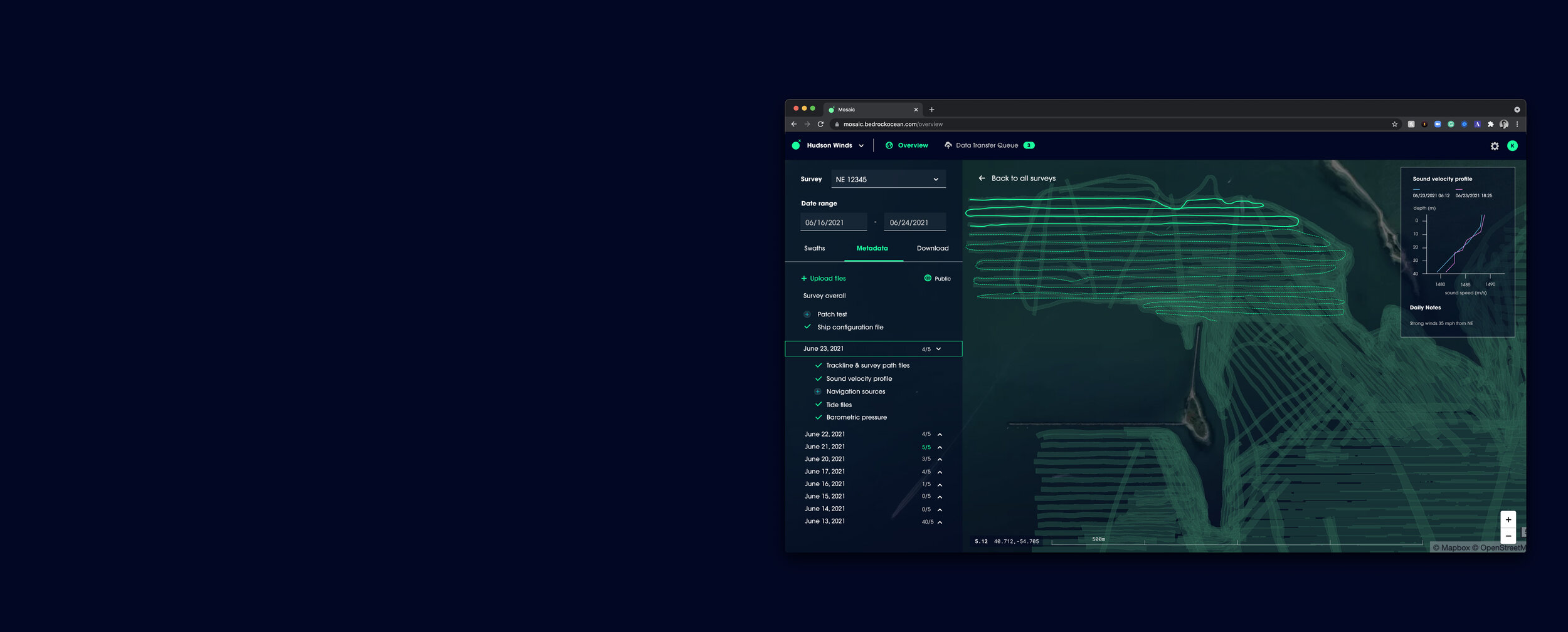
Mosaic™ supports massive uploads & downloads into the cloud. It handles the organization and identifies file problems within a survey quickly. We handle the data logistics associated with getting survey data into the right hands quickly, across your own organization or others that need access to it.

-

Accessible From Anywhere
No. More. Shipping. Hard Drives.
-

Data Sharing Made Easy
Access data in a single, permissioned place.
-

Data Management At Scale
Organize raw, metadata, & processed data.
-

Collaboration Across Teams
Share surveys instantly with others.
-

Data Security In The Cloud
Enjoy state-of-the-art cloud infrastructure.
-

Custom Data Integration
A custom API if you need more.
From Raw to Processed to Insights.
Accelerate your seafloor data workflows.
No matter who you are in the workflow—data owner, surveyor, project manager, researcher—Mosaic™ allows you to access, distribute, and manage raw and processed survey data across your organization and any third party. We provide the building blocks for a modern seafloor data infrastructure so surveys are no longer siloed. Thanks to Mosaic™ the handling of seafloor data becomes scalable. Secure your data in the cloud and deliver it with ease. Connect any relevant third-party organization, manage user access as you go, and run different survey projects in parallel.

Pricing & Plans
For Individuals
Free
(No credit card required)
Store up to 50GB of Private Seafloor Data
Freely access & publish to the public map
Single User Only
Cancel Anytime
For Small Teams
$65/mo
($780 annually)
14-day Free Trial
Store 500GB of Private Seafloor Data
GB-sized Uploads & Downloads
Unlimited Surveys
Unlimited Users in Org
For Organizations
$325/mo
($3,900 annually)
14-day Free Trial
Store 6TB of Private Seafloor Data
TB-sized Uploads & Downloads
Unlimited Surveys
Unlimited User in Org
For Enterprises
Custom
(For Tailored Needs)
Up to PBs of storage
Custom Data Ingestion
API - Ready
Enterprise Support

Making it easy to access public data.
Easily access and contribute to a free public map of our seafloor.
As a public benefit corporation, we’re here to also provide a free public map of our oceans. We’ve begun ingesting NOAA NCEI DCBC’s survey database to make it even more accessible to the public and systems.
Mosaic™
FAQs
Where does Mosaic™ sit in the data workflow?
Think of Mosaic™ as the replacement to shipping hard drives. Data is collected at sea, but processing may be done from anywhere in the world. It no longer matters where end-users of the raw and processed data are located. Mosaic™ manages your data every step of the way.
You say cloud ‘infrastructure’… I thought this was cloud software?
The infrastructure is what makes everything else possible, such as enabling machine learning algorithms to analyze seafloor data. True cloud software requires different data formats, different database structures, and different ways to interlink computers in parallel to accomplish tasks.
Does this replace my GIS solution?
No. But Mosaic™ will help you get your seafloor data into a GIS solution faster and our API allows you to ingrate with third-party solutions as needed. ESRI, QGIS, Google Earth, or Carto are great tools to analyze processed datasets. We simply help remove the barriers.
What makes Mosaic™ different?
Mosaic™ allows the entire raw and meta data set to live in one place. You can slice and dice data sets and download them locally from anywhere to process relevant data in your existing processing suites. It offers data access and transparency throughout the entire survey project.
Why can you process data faster and more efficiently?
What makes this all possible is our cloud infrastructure, optimized to store and process survey data. Mosaic’s cloud architectures offer advanced compute capabilities, which can be scaled dynamically. It’s a new way to work with survey data, which we improve constantly.
Do you have an API?
Yes. We engineered specific backend needs to help correctly store and access raw as well as processed data, including any required metadata. If you want to leverage our API to integrate seafloor data into your existing application or GIS tool, please contact us directly.

Turning surveys into a modern data product.
Bedrock offers the world’s first vertically integrated ocean-mapping platform. Learn more and request a survey today.